TRACING DE SOTO'S JOURNEY


|

|

|
August 2022
Bradenton, Fl.
|

|
|
At the park's visitors center, you are met by fascinating exhibits, a video history lesson and opportunities (lol) to take selfies with a mask-wearing Spanish conquistador. What more can you ask for?
But once you go out to explore the jungle on the "De Soto Expedition Trail," you find life size images of Native Americans and conquistadors scattered throughout the place. You are not just trekking through a tropical forest here; from the markers along the way, you are getting an education! |

|
|
Here you learn that, in 1538, Spanish King Charles V granted De Soto a royal contract to govern Cuba and “conquer, pacify and populate” La Florida - the land that Juan Ponce de Leon had discovered in 1513 and failed to conquer when he returned in 1521. And the land that another conquistador, Panfilo de Narvaez, had also failed to conquer 1528.
You learn that De Soto was already a wealthy and renowned conquistador from having plundered the Inca empire in Peru, that he invested his fortune on the new expedition and came to Florida seeking similar fortune. You learn that he led a nine-ship flotilla with close to 700 men, a few women, 350 horses, a herd of pigs, several packs of bloodhounds and "equipment necessary to sustain an expedition of conquest." |

You see? LOL Even the conquistadors wore masks!
|
|
Since La Florida was then understood to be much bigger than the current State of Florida, De Soto understood his commission to cover limitless territory. And so you learn that "in their relentless pursuit of gold and riches," De Soto's army spent the next four years exploring "much of the interior of southern United States, from Florida to Texas."
You learn that De Soto first established a base camp at the Indian village of Uzita, and within this park, you visit a small replica of the Uzita camp. |
|


|
You learn that this lush mangrove forest once covered much of the Tampa Bay coastline and presented an almost impenetrable obstacle for the De Soto expedition.
As I explain in a Chapter 49, On the Trail of Conquistadors, because they were cutting through mangroves, while herding pigs, horses, war dogs and fighting natives who stood in their way, it took them three months just to reach the Florida panhandle - less than a five-hour drive nowadays! When they reached the Apalachee village of Anhaica, in what is now Tallahassee, Fl., they fought with the natives, settled for the winter, and celebrated the first Christmas in what is now the United States. See: America's First Christmas was Celebrated in Spanish. |
|


|
Their four-year, 4,000-mile hike finally lost its drive when De Soto died of fever and was buried in the Mississippi River in 1542.
In this park you see that, contrary to popular belief, Florida natives were already a warring people when the Spanish arrived. You learn that before the Spanish raided Indian villages, the Indians were already raiding each other's villages. On the contrary, you also learn that De Soto had vowed to kill any Indian who would dare lie or betrayed him. Clearly, this park tries to be objective in its presentation of the Spanish conquistadors and those first encounters with native Americans. Without holding back, it shows that both were equally violent. Two more examples: |
|


|
“Emboldened by the conquest of the gold-rich Aztec and Inca civilizations in Central and South America several years earlier, the Spaniards came prepared for battle with armor, helmets, arquebus, crossbow, lance or pike in hand, some on horseback or with war dogs,” one marker explains.
“Those people are so warlike and so quick,” another marker quotes a conquistador. “Before a crossbowman can fire a shot, an Indian can shoot three or four arrows, and very seldom does he miss what he shoots at.” This park asks you to deal with the reality of living in 16th-century Florida! For our next stop, let's visit the landing site of the 1528 De Narvaez expedition. It's only 35 miles north of here! |

|

Hernando de Soto in Bradenton, Fl.While the east coast of Florida mostly honors Juan Ponce de Leon, now that we have reached the west coast I expect to see similar honors -- for Hernando de Soto!
After all, the 1539 De Soto expedition landed near here before trekking north across territory that later became the states of Florida, Georgia, South Carolina, North Carolina, Tennessee, Alabama, Mississippi, Arkansas and Louisiana. Their four-year, 4,000-mile hike finally lost its drive when de Soto died of fever at the banks of the Mississippi River, where he was buried in 1542. That's some 265 years before the much more acclaimed Lewis and Clark expedition. Yet here and along the west coast of Florida, and in many of the states De Soto explored, there are landmarks and historical markers recognizing that "the De Soto expedition came through here." I intend to visit some of them. This De Soto statue guards the Bishop Museum of Science and Nature in Bradenton, Fl. In this city, they even have a De Soto Historical Society! Unfortunately, they were closed when I drove by their offices, so I went back ON THE ROAD AGAIN! But we don't have to go far for our next stop. Some six miles west of here is the De Soto National Memorial. Let's go there next. |
|


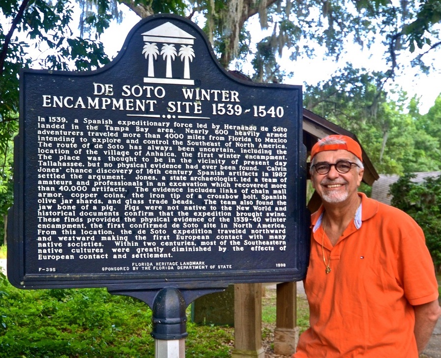
De Soto's winter encampment
|
To enlarge these images, click on them!
|
|
Jones, a state archaeologist, led a team of amateurs and professionals in an excavation which recovered more than 40,000 artifacts . . . These finds provided the physical evidence of the 1539-40 winter encampment, the first confirmed De Soto site in North America."
After the Spanish took over Anhaica, which had been forcibly abandoned by its Apalachee natives, they were under constant attack by the Apalachees. According to the signs here, perhaps that is the reason why accounts of that portion of the expedition mostly detail those raids and fail to mention Christmas celebrations. |
|


|
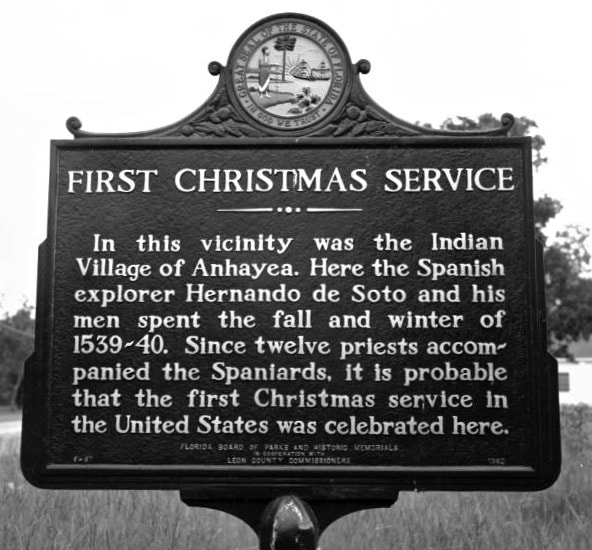
Yet historians believe that "the three priests who accompanied the De Soto expedition would have ensured that Christmas traditions were upheld,"
according to another sign titled "De Soto's Christmas in Tallahassee." The signs also explains that, "from this location the De Soto expedition traveled northward and westward making the first European contact with many native societies." We are not heading west folks, not on this road trip. But since we are heading north, I say we should follow De Soto's route, at least through Georgia and the Carolinas? Are you coming? |
|


Hernando de Soto
|

|
|
"His exact route is unknown and certain landmarks mentioned by the scribe of the expedition remain unidentified," the marker explains. Yet it also notes that Alligator Spring, near Arlington, “has the best claims of existing springs to identification with the ‘White Spring’ (Fuente Blanca) at which Hernando de Soto and his army encamped on the night of March 17-18, 1540.”
The De Soto expedition trekked across territory that later became Florida, Georgia, South Carolina, North Carolina, Tennessee, Alabama, Mississippi, Arkansas and Louisiana. Their four-year, 4,000-mile hike finally lost its drive when de Soto died of fever at the banks of the Mississippi River, where he was buried in May 1542. I don't intend to follow those footsteps, lol, but I say we should keep looking for historical markers on our way north! Are you coming? |
|


Following the Trail of Conquistadors in Milledgeville, Ga.Some 175 miles north of Arlington, Ga., where we found a historical marker for the Hernando de Soto expedition, another Georgia town still recognizes their route. "Many scholars believe that this was the general area where the De Soto expedition visited April 3-8, 1540," says the historical marker in downtown Milledgeville, Ga.
"In May 1539 Hernando de Soto landed in Florida with over 600 people, 220 horses and mules, and a herd reserved for famine," the marker claims. "Fired by his success in Pizarro's conquest of Peru, De Soto had been granted the rights, by the King of Spain, to explore, then govern, southeastern North America." |

|
|
After spending the winter in the Tallahassee area, the expedition "set out on a quest for gold which eventually spanned four years and crossed portions of nine states," the marker says. While recognizing that "this tremendous effort" forever changed the lives of the Indians who were infected with old world disease or killed in battle, the marker also notes that "this was the first recorded European exploration of the interior of the Southeast" and that "over 300 members died on the expedition, including De Soto in 1542."
The marker also explains that the Indians of the Chiefdom of Altamaha "ferried the Spanish across a large river in dugout canoes" and traveled northeastward. And wouldn't you know it? That's the direction we are taking! We are not taking canoes, lol, but on this road trip we are following the trail of conquistadors! Are you coming? |
|


Following De Soto's Trail
|

|
|
Here in western North Carolina, a part of the country where four current U.S. states nearly meet — Georgia, South Carolina, North Carolina and Tennessee — the De Soto expedition went as far northeast at the village of Joara (near present-day Morganton, N.C.), then changed course and began heading southwest across portions of Tennessee, Alabama, Mississippi, Arkansas and Louisiana, until they found the Mississippi River.
Their journey took four years and 4,000 miles, wiggling across today's U.S. map from Tampa Bay to Mexico. But the expedition lost its leader and will to keep exploring when De Soto died of a fever and was buried in the Mississippi River in May of 1542. Dodging attacks by natives, the survivors made their way to Mexico, where they knew they could hook up with other Spaniards. Of some 600 who started this journey, some 300 survived. |

|
|
But when the expedition was here and crossed the Little Tennessee River in western North Carolina, De Soto was already leading them back in a southwestern direction.
Nevertheless, I say we should keep going north to Joara. After all, some 27 years after De Soto was there, other Spanish explorers built a fort there. Let's go! |
|


April 2024
De Soto's Route in TennesseeHaving already followed the path of the 1539-43 Hernando De Soto expedition, through Florida, Georgia, South Carolina, and North Carolina in August of 2022, for my new trip, I picked up their trace in McDonald, Tennessee.
Here you find that the expedition followed Native American paths and passed near this spot in 1540. The marker, erected by the Tennessee Historical Commission, is at the intersection of South Lee Highway (U.S. 64) and south McDonald Road. |
|


Hernando De Soto's Trail in AlabamaSouth of Chattanooga, Tennessee, across the northwest corner of Georgia, and soon after entering Alabama, heading southwest on I-59, you find a visitor's center where the first European visitors to this area are recognized. (See map). The Spanish expedition led by Hernando De Soto came through here some 67 years before British colonists came to Virginia.
"Hernando de Soto brought his 700-man army to Alabama in the fall of 1540," a two-sided historical marker explains. "This was the first major European expedition to the interior of the southeastern United States. The De Soto expedition had landed at Tampa Bay, Florida, in the spring of 1539 – 47 years after Columbus discovered America. They traveled through parts of Florida, Georgia, North and South Carolina, Tennessee, Alabama, Mississippi, Arkansas, Louisiana, and Texas before abandoning their goals of finding riches and leaving for Mexico in 1543." Over the years, anthropologists and historians have developed various hypothesis to describe the actual route taken by De Soto – but they still don't know the specific trail! "Archaeologists believe that they know the general route that De Soto followed and are trying to locate the specific towns he visited in order to verify their theories," the marker explains. An "official" route was determined by a national commission in 1939. But anthropological work has altered the route since then. In creating these makers, with very eye-catching maps, the State of Alabama adopted the trail promoted in 1988 by Dr. Charles Hudson, of the University of Georgia, and his associates. The marker even outlines "The Highway Route of the De Soto Trail," which is "intended to follow the actual trail as closely as major highways permit," and which is precisely what I'm doing on this road trip! In Alabama, the marker explains that De Soto was betrayed by Indian chief Tascalusa. "The chief, resentful of the harsh Spanish treatment of the Indians, promised De Soto supplies and bearers at one of his small towns, Mabila. But there on October 18, 1540, De Soto and his advance party were ambushed by Tascalusa after they entered the town." When De Soto called up the main body of his troops and fought an all-day battle, more than 20 Spaniards and 2,500 Indians were killed in what the marker describes as "the greatest Indian battle ever fought in America." The Spanish prevailed, but the battle was a turning point for the expedition. "De Soto discovered no gold or silver, and an unsuccessful exploration had now turned into a near-defeat with major casualties," the maker elaborates. "The expedition continued slowly on toward Mississippi. The next three years would see the discovery of the Mississippi River, the death of De Soto from fever, and the eventual retreat of some 300 survivors to Mexico." Well, this time we are driving toward Mississippi, and my Great Hispanic American History Tour is moving a lot faster. Are you coming? |


|

DeSoto Falls, an unexpected natural beauty in AlabamaIn my effort to follow the route taken by the Hernando De Soto expedition, by visiting monuments and historical markers that recognize he was there, I found that there are towns, counties, parks, streets, waterfalls and even caverns that bear his name, not because he was there, but because he was in the general area.
For me, perhaps most impressive was DeSoto Falls, which is in DeSoto State Park, on Lookout Mountain, 8 miles northeast of Fort Payne, Alabama. When I went there, I wasn’t expecting such natural beauty! These 104-foot falls, the tallest in Alabama, have carved their own small canyon! The 3,502-acres, mountain terrain park, the largest in Alabama, has forests, rivers and waterfalls — the kind of turf the De Soto expedition encountered in 1540, as it trekked across territory that now covers 10 American states. The park was established in 1935 and named after the Spanish explorer when it was dedicated in 1939. Check out the two short videos below: |

|
|
|

|

Historic (Hispanic) Childersburg: The Oldest City in America?I saw it called Cosa, Coosa and Coca, but nevertheless it was the Native American Village visited by the Hernando De Soto expedition in 1540 and now known as Childersburg, Alabama.
De Soto's visit is still notable here, in monuments and historical markers that help citizens remember the town's Indian and Spanish roots. In fact, because it was visited by De Soto in 1540, some 25 years before the Spanish established a colony in St. Augustine, Fl., Childersburg city officials have been known to call it "The Oldest City in America." Of course, there is a huge difference between visiting an Indian village in 1540 and establishing a Spanish colony in 1565. In my book, that still makes St. Augustine the oldest, continuously-inhabited European city in the U.S.A., beating British Jamestown, Va. by 42 years. Nevertheless, Childersburg, incorporated in 1889 and home to close to 5,00 residents, proudly claims its Indian and Spanish heritage. “Childersburg traces its heritage to the Coosa Indian village located in the area,"notes one of the historical markers on the corner of First Street SW (Alabama-76) and Sixth Avenue SW, near the Childersburg police headquarters. "DeSoto, accompanied by 600 men, began his March across North America in June 1539. Traveling from Tampa Bay, Florida, northward through what became the Southeastern United States, DeSoto’s expedition began searching for riches.” After trekking north through present-day Florida, Georgia, South Carolina and reaching as far north as present-day North Carolina and Tennessee, the expedition was heading back southward when it reached present-day Alabama. “Upon entering the area that would become Alabama, DeSoto and his men marched southward along the Tennessee River,” the historical marker explains. “On July 16, 1540, the army of Spaniards entered the town of Coca (Coosa) located on the east bank of the river between two creeks, now known as Talladega and Tallaseehatchee.” That’s the current location of Childersburg. The marker explains that DeSoto was greeted by the chief of the Coosas. “For approximately a month, these invaders enjoyed the hospitality of the chief and his tribe, receiving an offer of land to establish a Spanish colony. After offering reasons for not accepting, the Spaniards departed Coosa in August 1540, leaving behind members of the expedition.” Another marker notes that, “Beginning with men left by DeSoto and continuing during a period of approximately 250 years, explorers, conquistadors, traders, and pioneer settlers penetrated the vicinity and occupied the area that is today known as Childersburg, Alabama.” As for the "men left by DeSoto," local folklore says that least one Spanish soldier, who was apparently too ill to travel, remained behind to live with the natives. But to follow De Soto's trail, we must now head northwest, into northern Mississippi. Are you coming? |


From my home in New Jersey, to McDonald, Tennessee, to DeSoto Falls, Alabama, to Childersburg, Alabama.
|


My Great Hispanic American History Tour Goes to Mississippi! Are you coming?Are you following my new road trip? We're just entering northeast Mississippi as I keep tracing the route taken by the Hernando de Soto expedition in 1539-43. If you have followed my other cross-country road trips, and this website, you know that my goal is to create a "Bucket List of Places, Ideas and Historical Evidence to Reconnect Americans with their Hispanic Roots."
But I need your help in divulging this information! Please SHARE my history postings with friends who would be interested in learning more about our Hispanic history in what is now the U.S.A. My goal is huge, and I cannot achieve it alone. ™Me ayudas? |

|

Siglos antes de que Elvis naciera aquí, Hernando exploró esta zonaTupelo, Mississippi — Unos 395 años antes de que Elvis Presley naciera aquí y pusiera este pequeño pueblo en el mapa, los exploradores españoles ya estaban dibujando mapas de esta zona.
Su presencia se reconoce en una esquina destacada de las calles Main y Church en el centro de Tupelo, donde un pequeño monumento conmemora a "Hernando De Soto y sus hombres, quienes pasaron el invierno de 1540-1541 en el noreste de Mississippi antes de su descubrimiento del río Mississippi". Tupelo es una ciudad de unas 38.000 personas. El monumento a De Soto es menos conocido que el lugar de nacimiento de Elvis en 1935, ahora un pequeño museo. Pero sigue siendo un hito importante más que documenta el viaje de cientos de exploradores españoles a través del suroeste de lo que hoy es Estados Unidos. Eso fue unos 67 años antes de que los colonos británicos llegaran a Virginia y unos 264 años antes de que Lewis y Clark se embarcaran expedición mucho más celebrada. Después de dirigirse al suroeste desde las Carolinas y Tennessee, y tras cruzar el actual norte de Alabama, la expedición giró hacia el noroeste cuando llegó al actual Mississippi. (Ver mapa). Mi Gran Gira por la Historia Hispano Americana va por ese camino. ™Vienes? |
|


A historical scare! ´Un susto histórico!
|
There I was, excited to be on yet one more of my Hispanic history research road trips, this time following the trail of the 1539-1543 Hernando de Soto expedition across the Southeast, and it wasn't my car that was breaking down. lol
When I got up one morning, in Tupelo, Mississippi, ready to grab the wheel for another long drive, I realized that my fingertips were numb. Concerned about what could be the cause, and realizing that tornado warnings were going to keep me off the road anyway, I paid a visit to the North Mississippi Medical Center, a huge and impressive hospital recommended by my hotel clerk. I must admit, driving myself to ER in a hospital several states away from home was a little unnerving, especially after the medial staff there took my condition very seriously. Their questions made me believe that they thought I had suffered a stroke! "But I'm following De Soto's trail and my next stop is supposed to be in a town called Hernando in a county called DeSoto," I kept telling everyone who would listen. I kept trying to add some humor to the situation as I was getting rolled on a stretcher from one medical exam to another. "I can't stop now!" I kept saying. "I LIVE FOR THIS!" They must have thought I was losing my mind. lol But in the end, I think they realized that I'm still somewhat sane. lol After a very long day undergoing every conceivable medical test they could think of, a group my new history students came to my room to give me the news that all my test were negative and, thank God, they were giving me a green light to go on with my journey. They told me the numbing of my fingers was probably from the tension of grabbing the wheel and driving too many consecutive hours and suggested I consider a slower pace, a maximum of four to five hours per day. I did, and it worked! "But before you leave, you must do me a favor," said one doctor in such a serious tone that I expected some bad news after all. He pointed to the tray of hospital food that had just been brought into my room and said, "Please don't eat this. Go get yourself a decent meal." I asked for "the best Mexican restaurant in Tupelo" and he gave me a prescription: "Cantina del Sol," he said without hesitation. So, I don't know whether it was the relief of knowing that the threat of tornados had passed, or that all my hospital tests came back negative, or of being discharged by a doctor with a great sense of humor, but Cantina del Sol was exceptional! |
|


A town named
|
|


To see De Soto's great discovery and burial, come to court!If you know anything about Spanish explorer Hernando De Soto, you know that he discovered the Mississippi River and that he was eventually buried in its waters. But unless you have visited the county courthouse of DeSoto, Mississippi, your mind probably does not register the images of those historic events.
This is where beautiful canvas murals illustrate those moments and let you see what you had only read. In "Hernando DeSoto Discovers the Mississippi River May 1541," you see the moment when a Native American guide points toward the Mississippi River, and De Soto and his men become the first Europeans to see it. "De Soto was eager to continue westward in search of gold and glory," says the small sign accompanying the mural. "To avoid attack by bands of Southeastern Indians patrolling the river, De Soto and his men crossed the Mississippi at night, guided by the light of a full moon." In a mural called "DeSoto's Burial in Mississippi River," you see the moonlight ceremony before his body was interned on the western banks of the river, either in present-day Arkansas or Louisiana. "Because the Soto had portrayed himself as an immoral son of God to gain control over southeastern Indians, his men feared attacks if De Soto's death should become known," a sign explains. "Instead of digging a gravesite, De Soto’s men wrapped his body with weights and sank it in the Mississippi River during the night . . . The exact location of De Soto’s burial is not known, and his remains have never been found."
While a sign here explain that "diseases introduced by Europeans killed a large portion of the native population," another sign notes that De Soto was 42 when he died of "a fever." So, clearly European deseases were also killing European explorers in the Americas. In "De Soto's Embarkation 1538," you see a mural illustrating the expedition disembarking from Havana on its way to Florida. And in "DeSoto guided through the forests," you see how the expedition was guided by Native Americans. Although there are nine murals in the courthouse, luckily for me, the four illustrating the De Soto expedition are in the building's rotunda and readily available to the public. The other paintings, in less-accessible courtrooms, depict the expeditions led by French-Canadian explorers Louis Joliet, Jacques Marquette and Jean-Baptiste Le Moyne de Bienville. The nine murals, some of the largest ever painted by American muralist Newton Alonzo Wells, were first commissioned for the old Gayoso Hotel in Memphis, where they hung from 1903 to 1948. According to a historical marker here, when the hotel was renovated into Goldsmith's Department Store in 1948, the City of Hernando convinced owner Fred Goldsmith to donate the murals to the city. After the town raised $5,000 to restore the murals, they were installed in the DeSoto County Courthouse in 1953. Now they have a combined appraised value of more than $1 million, the maker says. At my next stop, I went to a museum and ended up at the site of a huge historic event. Stay tuned. |


To enlarge these photos, click on them!


|
Para ver el gran descubrimiento y entierro de De Soto, ´ven a la corte!Si sabes algo sobre el explorador español Hernando De Soto, sabes que descubrió el río Mississippi y que finalmente fue enterrado en sus aguas. Pero a menos que hayas visitado el palacio de justicia del condado de DeSoto, Mississippi, tu mente probablemente no registre las imágenes de esos acontecimientos históricos.
Aquí es donde hermosos murales en lienzo ilustran esos momentos y te permiten ver lo que solo habías leído. En "Hernando DeSoto descubre el río Mississippi, mayo de 1541", se ve el momento en que un guía nativo americano señala hacia el río Mississippi, y De Soto y sus hombres se convierten en los primeros europeos en verlo. "De Soto estaba ansioso por continuar hacia el oeste en busca de oro y gloria", dice el pequeño cartel que acompaña al mural. "Para evitar el ataque de bandas de indios del sudeste que patrullaban el río, De Soto y sus hombres cruzaron el Mississippi de noche, guiados por la luz de una luna llena". En un mural llamado "El entierro de DeSoto en el río Mississippi", se ve la ceremonia a la luz de la luna antes de que su cuerpo fuera enterrado en la orilla occidental del río, ya sea en la actual Arkansas o Luisiana. "Debido a que Soto se había presentado como un hijo inmoral de Dios para ganar control sobre los indios del sudeste, sus hombres temían ataques si se conociera la muerte de De Soto", explica un cartel. "En lugar de cavar una tumba, los hombres de De Soto envolvieron su cuerpo con pesas y lo hundieron en el río Mississippi durante la noche... Se desconoce el lugar exacto del entierro de De Soto y sus restos nunca han sido encontrados". Mientras que un letrero aquí explica que "las enfermedades introducidas por los europeos mataron a una gran parte de la población nativa", otro letrero señala que De Soto tenía 42 años cuando murió de "fiebre". Entonces, claramente las enfermedades europeas también estaban matando a los exploradores europeos en las Américas. En "El embarque de De Soto 1538", se ve un mural que ilustra la expedición que desembarca de La Habana rumbo a Florida. Y en "DeSoto guiado por los bosques", se ve cómo la expedición fue guiada por nativos americanos. Aunque hay nueve murales en el palacio de justicia, afortunadamente para mí, los cuatro que ilustran la expedición de De Soto se encuentran en la rotonda del edificio y están disponibles para el público. Las otras pinturas, en salas de audiencias menos accesibles, representan las expediciones dirigidas por los exploradores francocanadienses Louis Joliet, Jacques Marquette y Jean-Baptiste Le Moyne de Bienville. Los nueve murales, algunos de los más grandes jamás pintados por un muralista estadounidense Newton Alonzo Wells, fueron encargados por primera vez para el antiguo Hotel Gayoso en Memphis, donde estuvieron colgados desde 1903 hasta 1948. Según un marcador histórico aquí, cuando el hotel fue renovado y convertido en grandes almacenes Goldsmith's en 1948, la ciudad de Hernando convenció al propietario Fred Goldsmith para que donara los murales a la ciudad. Después de que la ciudad recaudó $5,000 para restaurar los murales, se instalaron en el juzgado del condado de DeSoto en 1953. Ahora tienen un valor tasado combinado de más de $1 millón, dice el marcador. En mi siguiente parada, fui a un museo y terminé en el lugar de un gran evento histórico. Manténganse al tanto. |

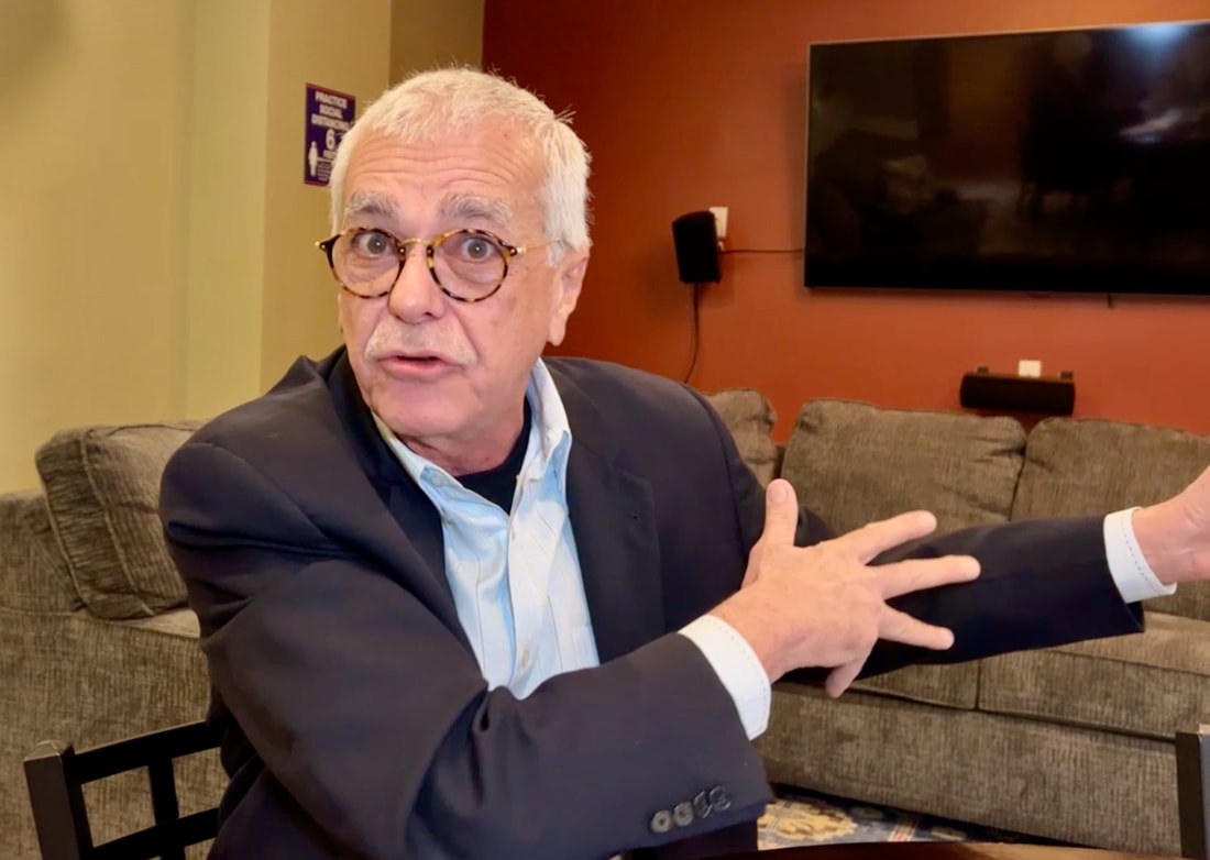
'Hernando De Soto stood here,' says Mississippi historianAfter visiting the DeSoto County Courthouse in Hernando, Mis., and seeing its wealth of art and history about Spanish explorer Hernando De Soto, for whom this city and county are named, it was hard to imagine a more impressive site for me to visit. But Hernando has a small museum and I could not leave town without stopping there first.
Yet shortly after arriving at the DeSoto County Museum, and describing my journey to the only person working there, Robert Long III gave me a pensive look for a few seconds and then shocked me. "I'm tracing De Soto's route," I told him. "I'm going to close the museum," he said. "Whaaat?" I asked. "Why?" "Because I'm going to take you to the spot where De Soto stood when he discovered the Mississippi River," he said. "And so," I said, cracking a huge smile, "what are we waiting for?" He took his car, I followed him in mine, and we drove for about a half hour out of town. When we finally stopped, northwest of Hernando, we were standing on a bluff overlooking a huge area where a body of water once stood, and where we could see the Mississippi in the distance. "This is it," he said. This is where it happened. De Soto stood here." He explained that the river once ran much closer to the bluff where we were standing because several centuries ago it was wider and unrestrained by development, making the historic bluff described by De Soto's explorers much more difficult to locate by archaeologists and historians. Yet, after many years of research, speculation and debate, Long says local historians now agree on the site he was showing me. De Soto saw the river from a distance then and we were seeing it from a much farther distance now, but it was the river that moved father away, said Long who is the museum's head curator and a presbyterian minister in Hernando. It took us another few minutes to drive to the river banks, at (wouldn't you know it?) the Hernando De Soto River Park. "Under the flag of Spain, Hernando De Soto's nine ships and 650 men landed in Tampa Bay in 1539," notes a historical marker at the park. "Hoping to find gold . . . they traveled to present-day North Carolina, then headed south and west, visiting northeast Mississippi before arriving at this point on May 8 1541." (See map). The park marker explains that for centuries before the Spanish arrived here, Indians lived, farmed, hunted, and build mounds along the river’s banks. It says that De Soto's men were the first documented Europeans to encounter the Indians and to cross the Mississippi. “De Soto's men had heard tales of this river, but they were stunned by his sheer size," the marker says. "Over the years the path of the river has changed, making it impossible to document the exact location of his of his river crossing." Also unknown is the spot where De Soto was buried, especially since his body was wrapped in sand-weighted blankets and sank in the river. He died on May 21, 1542, and his secret nighttime river burial was because his men feared attacks if Indians should learn of his passing. “After De Soto’s death, his army set out to find a land route through Texas to Mexico, but dwindling supplies forced them to turn back," the maker explains. "In June 1543 they set out down the Mississippi River. They sailed into the Gulf of Mexico six weeks later. No gold or other riches had been found.” Since the river now serves as the borderline between Mississippi and Arkansas, by crossing the river, the expedition began its exploration of present-day Arkansas. And so will we! But it's much easier nowadays. We can do it over a bridge. Can you guess what that bridge is called? |


|
'Hernando De Soto
|